
Mapping-level & Ultra-precision GNSS/MEMS INS
Introduction
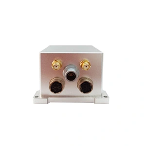
The ER-GNSS/MINS-01 MEMS IMU is a navigation solution that integrates satellite positioning and inertial measurement technology. It can provide navigation information with mapping level accuracy and is the most accurate integrated navigation system on the market that uses MEMS technology. It aims to overcome the inherent limitations of a single system and provide more continuous, reliable and accurate positioning, speed and attitude information.
ER-GNSS/MINS-01 can provide mapping-grade ultra-high-precision navigation information. It can quickly calculate a heading accuracy of 0.05°(up to 0.01°after post-processing) under complex GNSS conditions, and output an attitude accuracy of 0.01°(0.004°after post-processing), thus building a comprehensive, high-precision combined navigation data link.
It can also provide continuous high-precision position, attitude (accuracy 0.01°), and heading (accuracy 0.01°) output within 60 seconds of losing satellite signals.
Built-in high-reliability and extremely high-precision navigation-grade MEMS gyroscopes and MEMS accelerometers can accurately capture the angular velocity and acceleration information of the carrier, providing stable and reliable raw data for navigation solutions.
The dual-antenna full-system full-frequency positioning and directional satellite module is integrated internally, which has both single-antenna high-precision positioning and speed measurement and dual-antenna rapid orientation capabilities, can achieve centimeter-level positioning accuracy, and can also quickly and accurately determine the heading angle of the carrier, with high orientation accuracy and fast response speed, meeting the dynamic navigation needs of carriers such as land vehicles and drones.
It has multiple communication interfaces and provides standardized user communication protocols, which can quickly adapt to different platforms, significantly reduce the technical threshold for device interconnection, and realize seamless application in multiple scenarios of land and aviation.
Feature
1.Integrated navigation information with mapping-level accuracy, attitude can reach 0.01°, post-processing 0.004°, heading 0.05°, post-processing 0.01°.
2.In the environment where the satellite signal is lost, maintain high-precision navigation for 60 seconds, attitude (accuracy 0.01°) and heading (accuracy 0.01°).
3.High reliability and high precision MEMS gyroscope (bias instability <0.2°/h) and large range high precision MEMS accelerometer (±60g, bias instability <120ug).
4.The working temperature is -40℃~+80℃, and the temperature compensation of the gyroscope and accelerometer is carried out in the working temperature range, which has better bias performance.
5.Built-in full-band full-system dual-antenna positioning and orientation GNSS module, which supports single-antenna high-precision positioning and velocity measurement, and supports dual-antenna fast orientation function.
6.Supports RTK and can adaptively identify RTCM.
7.Variety of data interface, more easy to install and use, support RS422/RS232 and CAN
8.Precision aluminum alloy shell, high reliability, can be widely used in land, aviation, navigation.
Application areas
Large UAVs, flight data recorders
intelligent unmanned vehicles
Roadbed positioning and orientation
Specifications
1.System parameter
| ER-GNSS/MINS-01A | |
| Roll & Pitch Accuracy | 0.01° |
| 0.004° (Post Processing) | |
| Heading | 0.05° Dual Antenna GNSS (baseline 2m) |
| 0.01° (Post Processing) | |
| Speed Accuracy | 0.03m/s |
| Alignment Time | 3min (Dual Antenna GNSS) |
| 5min (No GNSS and in static environments) | |
| ER-GNSS/MINS-01B | ||
| Roll & Pitch Accuracy | 0.01° | |
| 0.004° (Post Processing) | ||
| Heading | 0.05° Dual Antenna GNSS (baseline 2m) | |
| 0.01° (Post Processing) | ||
| RTK 30 sec outage | Roll&Pitch | Heading |
| 0.01° | 0.01° | |
| Position (X/Y) | Altitude (Z) | |
| 0.2m | 0.08m | |
| RTK 60 sec outage | Roll&Pitch | Heading |
| 0.01° | 0.01° | |
| Position(X/Y) | Altitude(Z) | |
| 0.5m | 0.1m | |
| Speed accuracy | 0.03m/s | |
| Alignment Time | 3min (Dual Antenna GNSS) | |
| 5min (No GNSS and in static environments) | ||
2.Sensor parameter
| Gyro Performance | ||
| Item | Parameter | Unit |
| Range | ±200 | deg/s |
| Bandwidth (-3dB) | 50 | Hz |
| Scale Factor at 25℃ | 40000 | LSB/deg/s |
| Scale Factor Repeatability (1σ) | <100 | ppm |
| Scale Factor VS Temperature (1σ) | ±300 | ppm |
| Scale Factor Non-Linearity (1σ) | <300 | ppm |
| Bias stability (1σ 10s) | <0.5 | deg/hr |
| Bias Instability | <0.2 | deg/hr |
| Bias repeatability (1σ) | <0.5 | deg/hr |
| Angular Random Walk | <0.5 | °/ √h |
| Noise Peak to Peak | <0.04 | deg/s |
GNSS |
||||||||||||||||||||||||||||||||||
| Supported Navigation System | BDS/GPS/GLONASS/Galileo/QZSS | |||||||||||||||||||||||||||||||||
| Main ANT Frequency | BDS:B1L, B2L, B3L
GPS:L1C/A, L2P(Y)/L2C, L5 GLONASS: G1,G2 Galileo: E1, E5a, E5b QZSS: L1, L2, L5 |
|||||||||||||||||||||||||||||||||
| Slave ANT Frequency | BDS:B1L, B2L, B3L
GPS:L1C/A, L2C GLONASS: G1,G2 Galileo: E1, E5b QZSS: L1, L2 |
|||||||||||||||||||||||||||||||||
| Position Accuracy (RMS) | Single point positioning | Horizontal | 1.5m | |||||||||||||||||||||||||||||||
| Altitude | 2.5m | |||||||||||||||||||||||||||||||||
| DGPS | Horizontal | 0.4m+1ppm | ||||||||||||||||||||||||||||||||
| Altitude | 0.8m+1ppm | |||||||||||||||||||||||||||||||||
| RTK | Horizontal | 0.8cm+1ppm | ||||||||||||||||||||||||||||||||
| Altitude | 1.5cm+1ppm | |||||||||||||||||||||||||||||||||
| Accuracy of observation (RMS) | ||||||||||||||||||||||||||||||||||
| BDS | GPS | GLONASS | Galileo | |||||||||||||||||||||||||||||||
| B1I/L1 C/A/G1/E1 pseudo-range | 10cm | 10cm | 10cm | 10cm | ||||||||||||||||||||||||||||||
| B1I/L1 C/A/G1/E1 Carrier Phase | 1mm | 1mm | 1mm | 1mm | ||||||||||||||||||||||||||||||
| B3I/L2P(Y)/L2C/G2 pseudo-range | 10cm | 10cm | 10cm | 10cm | ||||||||||||||||||||||||||||||
| B3I/L2P(Y)/L2C/G2 Carrier Phase | 1mm | 1mm | 1mm | 1mm | ||||||||||||||||||||||||||||||
| B2I/L5/E5a/E5b pseudo-range | 10cm | 10cm | 10cm | 10cm | ||||||||||||||||||||||||||||||
| B2I/L5/E5a/E5b Carrier Phase | 1mm | 1mm | 1mm | 1mm | ||||||||||||||||||||||||||||||
| Time accuracy (RMS) | 20ns | |||||||||||||||||||||||||||||||||
| Speed accuracy (RMS) | 0.03m/s | |||||||||||||||||||||||||||||||||
| First positioning time | <30s | |||||||||||||||||||||||||||||||||
| Initialization time | <5s | |||||||||||||||||||||||||||||||||
| Data update rate | <20Hz | |||||||||||||||||||||||||||||||||
| Power & Interface | |
| Supply Voltage | 6~12V |
| Supply Consumption | 5W |
| Interface | 1Way-RS422 or 1Way-RS232 and 1Way-CAN and 2Way-TTL(NMEA out and RTCM in) |
| Environment | |
| Operate Temp | -40℃~+80℃ |
| Storage Temp | -55℃~+95℃ |
| Dimension & Weight | |
| Weight | <300g |
| Size | 65mm*70mm*45.5mm |
More Technical Questions
1. What Is GNSS-aided MEMS INS and How Does It Work?
2. How to Improve the Performance of MEMS Inertial Navigation Systems?
3. Full-temperature Performance Optimization Method For MEMS accelerometer
4. Classification And Performance Improvement Of MEMS Gyroscope
5. MEMS Accelerometer Packaging Technology
6. Performance Analysis of GNSS RTK Timing
More Products