
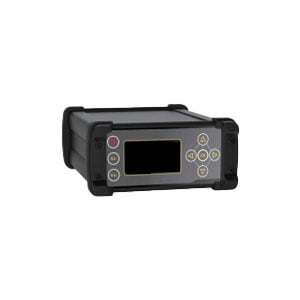
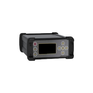
System-wide All-frequency Reference Station Receiver
ER-GNSS-R02 is a high-performance GNSS receiver designed by BDSTAR for the construction of Beidou ground-based enhancement system, with built-in Linux operating system, completely independent intellectual property development, rich interface types, diverse communication modes, support for external frequency standard input, event input and large-capacity data storage, and support for a variety of sensor input. It is the best choice for the construction of Beidou foundation enhancement system.
Features
Features 432 super channels and a dedicated fast capture engine
Support for BDS, GPS, GLONASS and Galileo
Adaptive resistance to narrowband interference up to 60dB
Based on the ARM Cortex-A7 design, the main frequency is up to 536MHz
Built-in 32G storage, can be downloaded remotely, support multi-channel cyclic storage
Support secondary development
Industrial grade design, strong aluminum alloy shell, in line with IP67 design requirements, safe and reliable
Specifications
| Performance index | |
| GNSS Receive Frequency | BDS B1I/B2I/B3I GPS L1/L2/L5 |
| Channels | GLONASS L1/L2 Galileo E1/E5a/E5b |
| 432 super-channels and dedicated fast-capture engine | |
| Pseudo-Range Observation Accuracy (RMS) | 10.0cm |
| Carrier Phase Observation Accuracy (RMS) | 1.0mm |
| Single-point positioning accuracy (RMS) | Plane 1.5m ;height 3.0m |
| RTK accuracy (horizontal) | Level: 1cm+1ppm; Vertical: 2cm+1ppm (built-in high precision board) |
| RTK positioning accuracy (RMS) | Horizontal: 0.8cm+1ppm
Elevation: 1.5cm+1ppm |
| Static accuracy (RMS) | Level: ± (2.5mm+1ppm)
Elevation: ± (5mm+1ppm) |
| Time Accuracy (RMS) | 20ns (*Excluding delays caused by RF cables or antennas) |
| Positioning data | NMEA-0183 |
| Differential data | RTCM3.0, RTCM3.2, RTCM3.3 |
| Storage format | RINEX, customized |
| Data refresh frequency | 1 Hz, 2 Hz, 5 Hz, 10 Hz, 20 Hz |
| Received data availability | ≥98%(available data/captured data) |
| Data completeness rate | ≥98% (data collected / data to be collected) |
| Interface Characteristics | |
| Serial port | Standard RS232 interface baud rate support 1200, 2400, 4800, 9600, 19200, 38400,115200, 230400bps |
| Network port | Standard RJ45 interface, 10/100Mbps network adaptive |
| WIFI | 2.4GHz, IEEE 802.11b/g/n |
| Mobile network (All Netcom) | LTE-TDD Band 38/39/40/41LTE-FDD Band 1/3/5/7/8
TD-SCDMA Band 34/39UMTS Baud 1/8 EVDO BC0 CDMA1x BC0 GSM Band 2/3/5/8 |
| Bluetooth | Version3.0 Transmit Class2 Frequency2.4~2.48GHz |
| Electrical Characteristics | |
| Voltage Input | Main port 2x10 header,2mm pitch |
| Special Voltage Input | 140~240V@50/60Hz AC Input (with special adapter) |
| Power Consumption(*Non-charging power consumption | 5.5W (typical value)
The above power consumption does not include the power consumption of battery charging |
| Built-in battery | 13000mAh@7.4V |
| Battery life | ≥15H
Brand new battery, supports 16 hours of operation under typical power consumption |
| Structural Characteristics | |
| Dimension | 212×162.5×74.5mm |
| Weight | ≤2.30kg |
| Protection Class | Dustproof waterproof IP67 Shock-proof GB/ T2423 |
| Working Environment | |
| Operating Temperature | -40~+65℃
The battery life decreases at -40℃ |
| Storage temperature | -40~+85℃ |
Application Techniques
1.Some Questions about GNSS Antenna
2.The Difference and Connection between GPS and GNSS
3.High-precision GNSS receiver design
4.Scientific Farming, With The Help of GNSS
5.The Working Principle of GNSS
More Products