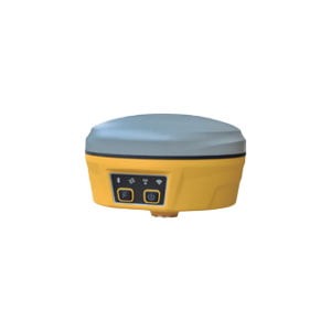
Full System Full Frequency Point Geodesic Receiver
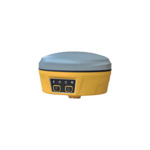
ER-GNSS-R03 is a high-end GNSS receiver, a new generation measurement engine, support tilt measurement, built-in 4G full Netcom, Bluetooth/WIFI and multi-protocol radio, with a new appearance design, magnesium alloy structure, Linux operating system, is an extreme, intelligent, lightweight measurement type GNSS receiver.
Features
Linux+Qualcomm MDM9628 Cortex-A7 intelligent system platform
Features 432 super channels and a dedicated fast capture engine
Supports BDS, GPS, GLONASS, Galileo, QZSS, SBAS
Centimeter-level positioning
Support tilt measurement, and meet the positioning accuracy of less than 2cm in the tilt range of 30°
Built-in large-capacity lithium battery, long battery life
Industrial-grade design, rugged magnesium alloy housing, IP67 design requirements, safe and reliable
Specifications
| Performance index | |||
| Hardware Platform | Qualcomm MDM9628 Cortex-A7 | ||
| Software Platform | Linux | ||
| GNSS | GPS | L1/L2/L5 | |
| GLONASS | L1/L2 | ||
| BDS | B1/B2/B3 | ||
| Galileo | E1/E5a/E5b | ||
| QZSS | L1/L2/L5 | ||
| SBAS | L1 | ||
| Supported Data Formats | NMEA-0183 | ||
| Correction volume I/O protocol | RTCM 2.X, RTCM3.X | ||
| Data update rate | MAX 5Hz | ||
| Recapture time | <1s | ||
| Cold start | <40s | ||
| Positioning Accuracy | Single-point positioning (RMS) | Plane: 1.5m; Elevation: 3.0m | |
| DGPS (RMS) | Plane: 0.4m; Elevation: 0.8m | ||
| RTK (RMS) | Plane: ±(10mm+1ppm)
Elevation: ±(15mm+1ppm) |
||
| Time accuracy (RMS) | 20ns | ||
| Static accuracy (RMS) | Horizontal: ±(2.5mm+1ppm)
Elevation: ±(5mm+1ppm) |
||
| Velocity accuracy (RMS) | 0.03m/s | ||
| Tilt compensation accuracy (within 30°) | <2cm | ||
| Bluetooth | V2.1+EDR/V4.0 Dual Mode | ||
| WIFI | 802.11 a/b/g/n/ac | ||
| Radio communication | External transmission: 5W/35W (external radio adjustable) | ||
| Built-in power: 0.5W/1.5W adjustable | |||
| Frequency: 410-470MHz | |||
| Communication protocol: TrimTalk,TrimMark3,SOUTH,PCC-EOT | |||
| System Platform | Network communication | Full network communication | |
| LTE FDD: B1/B3/B5/B8 | |||
| LTE TDD: B38/B39/B40/B41 | |||
| TD-SCDMA: B34/B39 | |||
| CDMA: BC0 | |||
| WCDMA: B1/B8 | |||
| GSM: 900/1800MHz | |||
| Indicator Lights | Built-in storage | onboard 32GB, available space 24GB | |
| Power Light | Power Indicator | ||
| Satellite light | Positioning status indicator | ||
| Bluetooth indicator I | Bluetooth connection status light | ||
| Data Link Light | Differential Data Link Light | ||
| Mobile network light | Mobile network status light | ||
| Battery | Specifications | 7.4V, 9750mAh | |
| Endurance 21 hours of continuous operation in static mode
12 hours of continuous operation in datalink mode with built-in radio in base station |
|||
| Environmental Characteristics | |||
| Operating Temperature | -20℃~+70℃ | ||
| Storage Temperature | -40℃~+85℃ | ||
| Seismic resistance | 2 meters with the rod at room temperature | ||
| Three protection level | IP67 | ||
| Physical Characteristics | |||
| Material | Magnesium alloy case+ABS/PC plastic top cover | ||
| Dimension | 156×156×102mm | ||
| Weight | 1.4kg | ||
| Accessories | |||
| M65 host | 1 unit | ||
| Radio feeder | 1 pc | ||
| 7-pole data cable | 1 pc | ||
| Power adapter | 1 pc | ||
Application Techniques
1.Some Questions about GNSS Antenna
2.The Difference and Connection between GPS and GNSS
3.High-precision GNSS receiver design
4.Scientific Farming, With The Help of GNSS
5.The Working Principle of GNSS
More Products
