

Inertial Measurement Unit, referred to as IMU, is defined as "a device that can measure three-dimensional linear motion and angular motion without external reference", that is, a device that measures the three-axis attitude angle (or angular rate) and acceleration of an object.
Composition of IMU
IMU consists of three single-axis accelerometers and three single-axis gyroscopes. The accelerometer is used to detect the acceleration signal of the object in the independent three axes of the carrier coordinate system, while the gyroscope is used to detect the angular velocity signal of the carrier relative to the navigation coordinate system, measure the angular velocity and acceleration of the object in three-dimensional space, and calculate the attitude of the object. Therefore, IMU has a very important application value in navigation.
Imagine a Cartesian coordinate system, as shown in the figure below, with an x-axis, a y-axis, and a z-axis. The sensor can measure linear motion in each axis direction and rotational motion around each axis. This is the fundamental starting point of all IMUs, and all inertial navigation systems are built on this basis.

Working principle of IMU
The principle of IMU is very similar to taking small steps in the dark. In the dark, due to the error between the estimated step length and the actual distance walked, the estimated position will be farther and farther away from the actual position as the number of steps increases. When taking the first step, the estimated position is relatively close to the actual position; but as the number of steps increases, the difference between the estimated position and the actual position becomes larger and larger. According to this method, it is extended to three dimensions, which is the principle of inertial measurement unit.
The academic statement is: based on Newton's laws of mechanics, by measuring the acceleration of the carrier in the inertial reference system, integrating it over time, and transforming it into the navigation coordinate system, the speed, yaw angle and position in the navigation coordinate system can be obtained.
Therefore, in layman's terms, the inertial measurement unit IMU belongs to the strapdown inertial navigation. The system consists of three acceleration sensors and three angular velocity sensors (gyroscopes). The accelerometer is used to sense the acceleration component relative to the vertical line of the ground, and the velocity sensor is used to sense the angle information.
It is worth noting that IMU provides relative positioning information. Its function is to measure the route of the object relative to the starting point, so it cannot provide information about your specific location. Therefore, it is often used together with GPS. When in some places where the GPS signal is weak, IMU can play its role, allowing the car to continue to obtain absolute position information and not get "lost".
Classification of IMU
Currently, the IMUs on the market are mainly 6-axis and 9-axis. The 6-axis IMU contains a 3-axis acceleration sensor and a 3-axis gyroscope; the 9-axis IMU has an additional 3-axis magnetometer. In addition, for IMUs using MEMS technology, a thermometer is generally built in for real-time temperature calibration.
Application of IMU
IMU is mostly used in equipment that requires motion control, such as cars and robots, and is also used in situations where precise displacement calculations are required using attitude, such as inertial navigation equipment for submarines, aircraft, missiles and spacecraft.
Compared with other navigation systems, inertial navigation systems have important characteristics such as comprehensive information, full autonomy, high concealment, real-time and continuous information, and are not restricted by time and region and are not interfered by human factors. They can work normally in various environments such as air, water, and underground.
For example, the above advantages of IMU are particularly evident in autonomous driving systems. In autonomous driving systems, IMU can be used as an effective supplement when other sensor data is missing. By calculating the vehicle's attitude (pitch and roll angles), heading, speed, and position changes, IMU can be used to fill the gaps between GNSS signal updates, and can even perform dead reckoning when GNSS and other sensors in the system fail. Therefore, as an independent data source, IMU can be used for short-term navigation and verify information from other sensors.
Some people say that the last line of defense for autonomous driving systems in the field of positioning is IMU, and there are three main reasons:
First, IMU has no external dependence on the deduction of relative and absolute positions, and is a complete system similar to a black box; in comparison, absolute positioning based on GPS depends on the coverage effect of satellite signals, and absolute positioning based on high-precision maps depends on the quality of perception and the performance of the algorithm, and the quality of perception is related to the weather and has certain uncertainties.
Secondly, because IMU does not require any external signals, it can be installed in areas that are not exposed, such as the chassis of the car, and can resist external electronic or mechanical attacks. In comparison, vision, laser, and millimeter waves must receive electromagnetic or light wave signals from the outside of the car when providing relative or absolute positioning, so they are easily blinded by electromagnetic waves or strong light signals from attackers, and are also easily damaged by unexpected situations such as stones and scratches.
Finally, the IMU measurement values of angular velocity and acceleration have a certain degree of redundancy, and coupled with redundant information such as wheel speed meters and steering wheel angles, the confidence of its output results is much higher than the absolute or relative positioning results provided by other sensors.
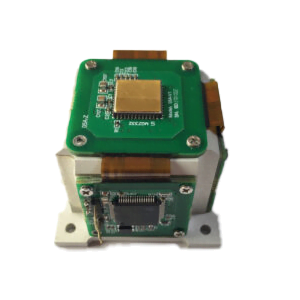
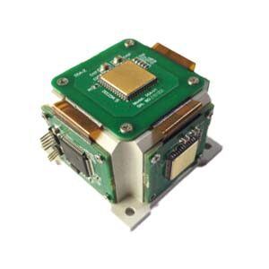
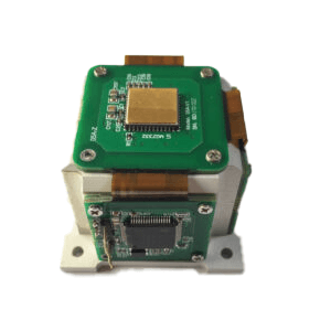
In short, in the complex and inexhaustible working conditions of autonomous driving, IMU provides the last line of security for the positioning system of autonomous driving with its ultra-high confidence, no external dependence, and strong anti-interference ability. ERICCO's self-developed small aircraft MEMS IMU, such as ER-MIMU-M01C:
Feature:
- Miniaturized IMU
- Low power consumption
- Low price
- Full temperature compensation
Application
Inertial navigation: combined navigation, platform stability
Attitude control: UAV
Automotive field: unmanned, electronic stability program
Application Techniques
1.IMU and GPS fusion algorithm principle
2.MEMS IMU error analysis and compensation
3.Reusable spacecraft IMU dynamic accuracy assessment method
4.Research on MEMS IMU error modeling and temperature compensation technology
5.Calibration method and error analysis of low-precision MEMS IMU
6.MEMS-IMU error calibration compensation method that does not rely on precision turntable
More Products
 High Performance MEMS IMU
 Low Power Consumption MEMS IMU
 Low Cost MEMS IMU